
| Location: Salt Lake City,UT,USA Member Since: Jul 23, 2006 Gender: Male Goal Type: Local Elite Running Accomplishments: 5k 16:16 / 10k 33:12 / half marathon 1:12:28/ marathon 2:32:59/ 100 miles: 34 hours, nine minutes (Wasatch 100).
Short-Term Running Goals: Compress six months of marathon training into six weeks.
Long-Term Running Goals: Stay curious.
Personal: I'm an attorney in Salt Lake City. Married to Heather. We have two little boys.
Favorite Blogs: |
|
Click to donate
to Ukraine's Armed Forces
|
| Miles: | This week: | 0.00 |
Month: | 0.00 |
Year: | 0.00 |
|
| | Easy Miles | Marathon Pace Miles | Threshold Miles | VO2 Max Miles | Crosstraining miles | Total Miles | | 47.00 | 0.00 | 0.00 | 0.00 | 0.00 | 47.00 |
|
| | Easy Miles | Marathon Pace Miles | Threshold Miles | VO2 Max Miles | Crosstraining miles | Total Miles | | 0.00 | 0.00 | 0.00 | 0.00 | 0.00 | 0.00 |
|
Travel day. SLC to Paris--Paris to Geneva. Geneva to Chamonix. Long day, no run.
| | Add Comment |
| | Easy Miles | Marathon Pace Miles | Threshold Miles | VO2 Max Miles | Crosstraining miles | Total Miles | | 8.00 | 0.00 | 0.00 | 0.00 | 0.00 | 8.00 |
| Went to bed late enough to try to adjust to the time change. Woke up at 6:45 and ran on the roads and trails that lead east out of the Chamonix valley. Connected on a double track paralleling the l'Arve river. Ended up gaining some altitude on a single track that climbed up the mountain side. Views of Mont Blanc over the glacial mist. | | Add Comment |
| | Easy Miles | Marathon Pace Miles | Threshold Miles | VO2 Max Miles | Crosstraining miles | Total Miles | | 10.00 | 0.00 | 0.00 | 0.00 | 0.00 | 10.00 |
|
AM: Another outstanding run in Chamonix. Paralleled the river,
tremendous climbs on single track forest trail surrounded by moss
covered stones, the sound of rushing glacial water, and overcast skies.
Top five, ever. There are trails everywhere. I could run here for a long, long time and never get bored. PM: First day of our trek along the Haute Route (Chamonix to Zermatt, Switzerland). Easy day of climbing up from the village of Le Tour, the highest village of the
valley of Chamonix, to Charamillon mountain pasture, 6,076 feet. From
there, easy traverse across the mountain until we were met with an amazing view of the "glacier du
Tour". Spent the night in "Albert 1er" hut, height 8,865 feet. Great view, terrible food and accommodations otherwise. We hiked 4 miles, I'll count it as 2 easy since we're carrying giant packs. It would be much easier to run 2 easy miles than do this.
| | Comments(1) |
| | Easy Miles | Marathon Pace Miles | Threshold Miles | VO2 Max Miles | Crosstraining miles | Total Miles | | 10.00 | 0.00 | 0.00 | 0.00 | 0.00 | 10.00 |
|
Haute Route, Day 2. We started hiking before dawn, roped up, put on crampons, and took out our ice axes for the first day of glacier climbing. We climbed up to the pass of Le Tour, 10,768 feet, on the
Swiss border. Heather was freaked by the climb and rock scramble up to the pass. Great views of the glacier of Trient, the " Aiguilles Dorées
", and all the summits of the Swiss Valais, including the Matterhorn. After the pass, we crossed over the Trient plateau to Orny pass, 10,164
feet, and Orny hut.
Had our first taste of Croute d'ouef et fromage (basically oil-dipped toasted bread covered with cheese and two eggs ... wow!). Followed the trail across Orny and took the Breya chairlift, 7,178 feet, down to Champex
village, 4,724 feet. From there, we shipped some stuff on to Zermatt because we had all overpacked and were burdened like pack mules! Took a mini-bus to the Chanrion hut, 8,077 feet,
right in Valais mountains. Had a terrifying ride that made me car sick. 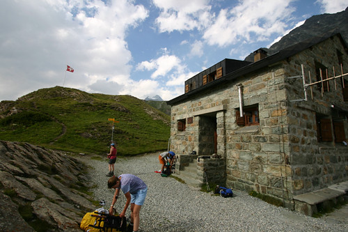
Approx 6 hours of hiking, Length
: 10 miles. Difference of elevation: 1,902 feet up, 3,596 feet down.
| | Add Comment |
| | Easy Miles | Marathon Pace Miles | Threshold Miles | VO2 Max Miles | Crosstraining miles | Total Miles | | 9.00 | 0.00 | 0.00 | 0.00 | 0.00 | 9.00 |
| Haute Route Day 3: Left the Chanrion hut just before sunrise. Had a three mile hike along great trails to the base of the Otemma glacier. This is an enormous expanse of ice that apparently moves down of nearly one foot
per day, due
to the persistent thrust of the glaciers of its basin. The climb along the glacier was fun, but very long--10k of basically straight walking with gentle elevation gain throughout. Our minds numbed during four hours of walking, we devolved into playing games like "Name a Fruit ... Any Fruit." There were no more rules than that. Nearby were the high, sharp peaks along the Italian border (Singla, 12,185 feet, Grand
Blanchen, 12,067 feet). We had a steep scramble up a boulder strewn ridge and were met with an awesome view of the Vignettes hut, which clings perilously to the mountainside. It has been described as an eagle nest built on the top of a vertical wall.This was unanimously the best hut on our trip. Great food and the hutkeepers were awesome. Our group of six (plus our guide) were the only ones there, except one other couple.

Hike duration: ~
6 hours.
Length : 9 miles.
Difference of elevation: 2,776 feet up, 492
feet down.
| | Add Comment |
| | Easy Miles | Marathon Pace Miles | Threshold Miles | VO2 Max Miles | Crosstraining miles | Total Miles | | 10.00 | 0.00 | 0.00 | 0.00 | 0.00 | 10.00 |
|
Haute Route Day 4. The plan was to leave the Vignettes hut and ascend the Evêque pass (11,128 feet), on the Italian border.
However, an overnight snowstorm and low visibility sent us on a different route. We climbed down the glacier below Vignettes and the Pigne d'Arrola to the bottom of the mountain and then climbed slowly back up the steep side of another mountain along winding single track. From Plans Bertol, we took the trail up along the moraine ridges until we encountered a small glacier. Above us loomed the Cabane Bertol, which made the Vignettes hut location look easy by comparison. We were roped up and climbing along narrow rock ledges with 500 foot exposure to reach steep ladders that accessed the hut. Spent the night in the hut at 10,863 feet. 
Duration of walking:
7 hours. Length : 10 miles. Difference of elevationl : 3,770 feet up, 3,268 feet down.
| | Add Comment |
| | Easy Miles | Marathon Pace Miles | Threshold Miles | VO2 Max Miles | Crosstraining miles | Total Miles | | 47.00 | 0.00 | 0.00 | 0.00 | 0.00 | 47.00 |
|
|
|
| Debt Reduction Calculator |
|
New Kids on the Blog
(need a welcome):
Lone Faithfuls
(need a comment):
|